The Administration should ensure that any EIA studies undertaken
for this project should be carried out at a VERY EARLY stage
in the process and not at the end of the design and planning
exercise, and that they should focus in particular on the
White Dolphin population in the area. More
...
The land fall of the Hong Kong-Zhuhai-Macau bridge link is
a major challenge in planning, environmental protection, highway
design as well as bridge operation. To date options still
remain open (Ming Pao 20030830). This paper will first highlight
the valuable geological landscape of the northwest Lantau
shoreline. A new route option which completely avoids touching
the shorelines will then be discussed. The option involves
crossing underneath the runway in bored tunnels through the
solid rock of the relic Lam Chau Island. The route was found
to be sound in operation and will have many additional benefits.
It is proposed that Government further examines the detailed
feasibility of this route.
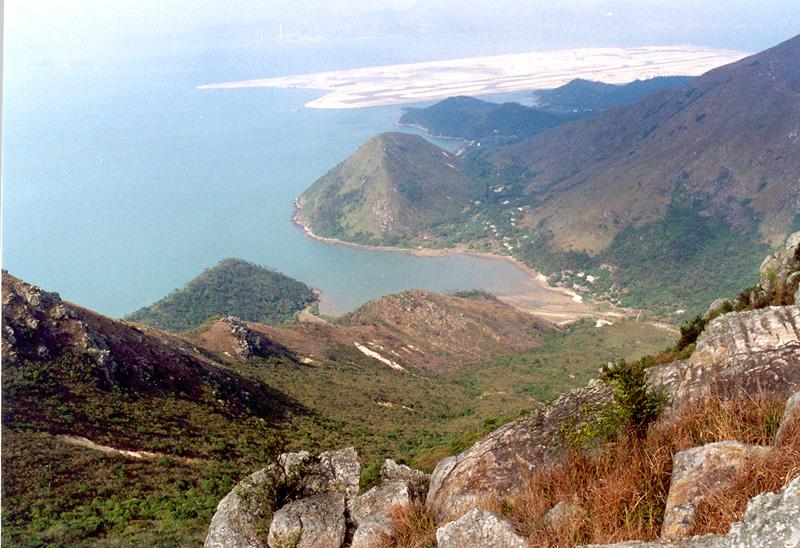
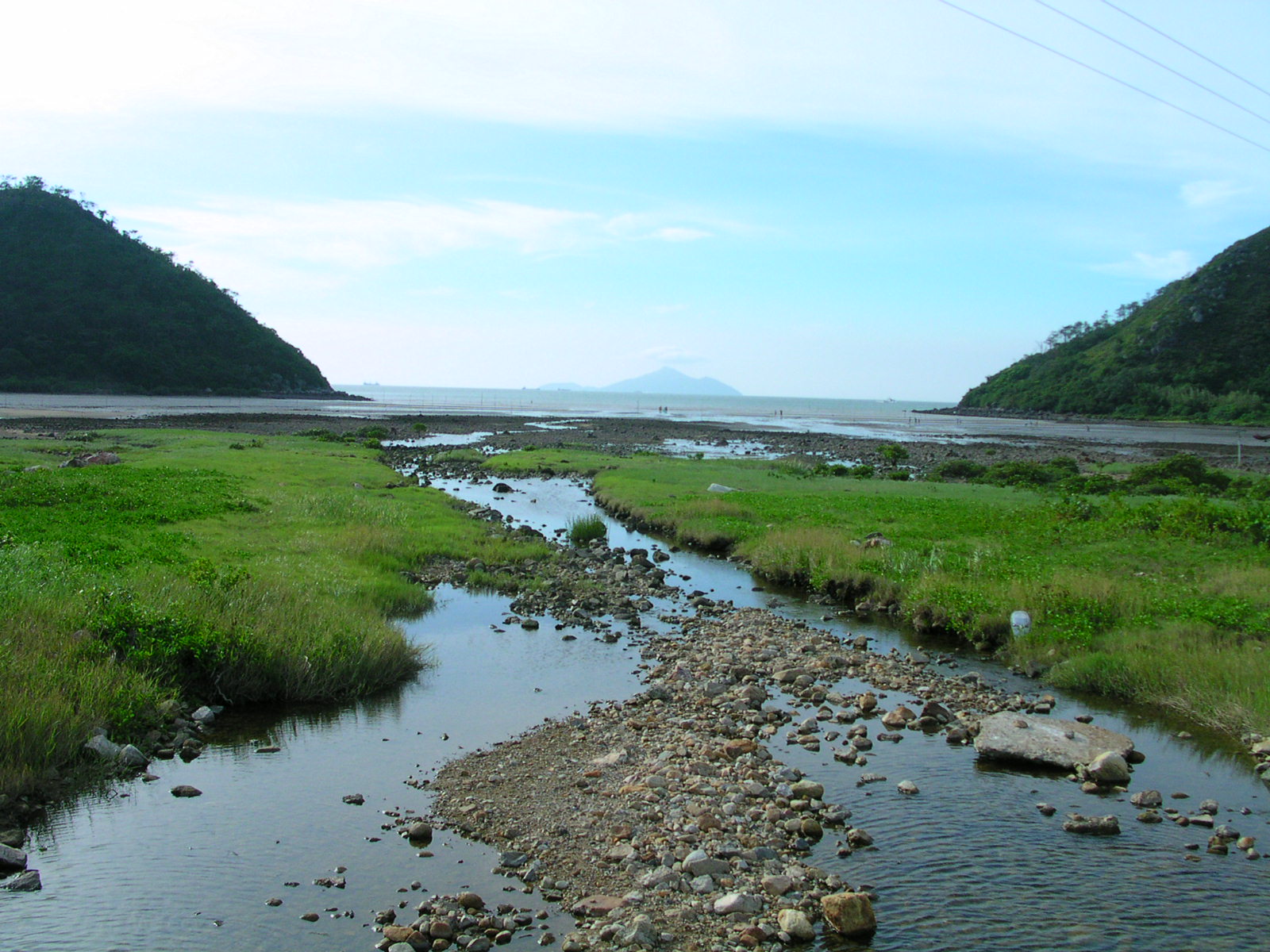
(Photos:Sham Wat Bay guarded by two escarpments with Hong
Kong Chek Lap Kok airport beyond)
The northwestern shoreline of Lantau Island is one of the
options being considered for the proposed Hong Kong –
Macau- Zhuhai Bridge Link. There are already serious concerns
about ecological impacts on wetland, water currents and white
dolphins. To date, impacts to the equally important landscape
heritage (Photo Plate) appears to have been largely unexplored..
The shoreline of Fu Shan Island to the north of Tai O is
famous for the “General Rock”. With a legendary
story, the peculiar natural sea arch resembles a military
general leaning against the hillside.
Although the precise alignment of the bridge has not been
announced, two possibilities can be inferred from press reports.
The first option involves a submarine tunnel to the north
of Sha Lo Wan which links up the airport island with an artificial
island north of San Shek Wan.
The second option involves a bridge between the airport island
and a site west of San Tau. The route then enters into a bored
tunnel in the hills behind Hau Hok Wan. The tunnel re-emerges
at San Shek Wan where the bridge commences. Some reports show
reclamations of the shorelines around San Shek Wan and Sham
Wat.
Both options have disadvantages in terms of costs, environmental
impact and proximity to the flight path. For this reason,
it is necessary to explore other options, including those
which involve crossing underneath the runway.
Crossing underneath a live runway and apron areas is not
new to Hong Kong. The existing Airport Tunnel at To Kwa Wan
was constructed by the “cut and covered” technique
in the 1970s. Construction was likely to be difficult due
to the ground conditions and restriction in working hours.
The current proposal will have far more favourable engineering
conditions.
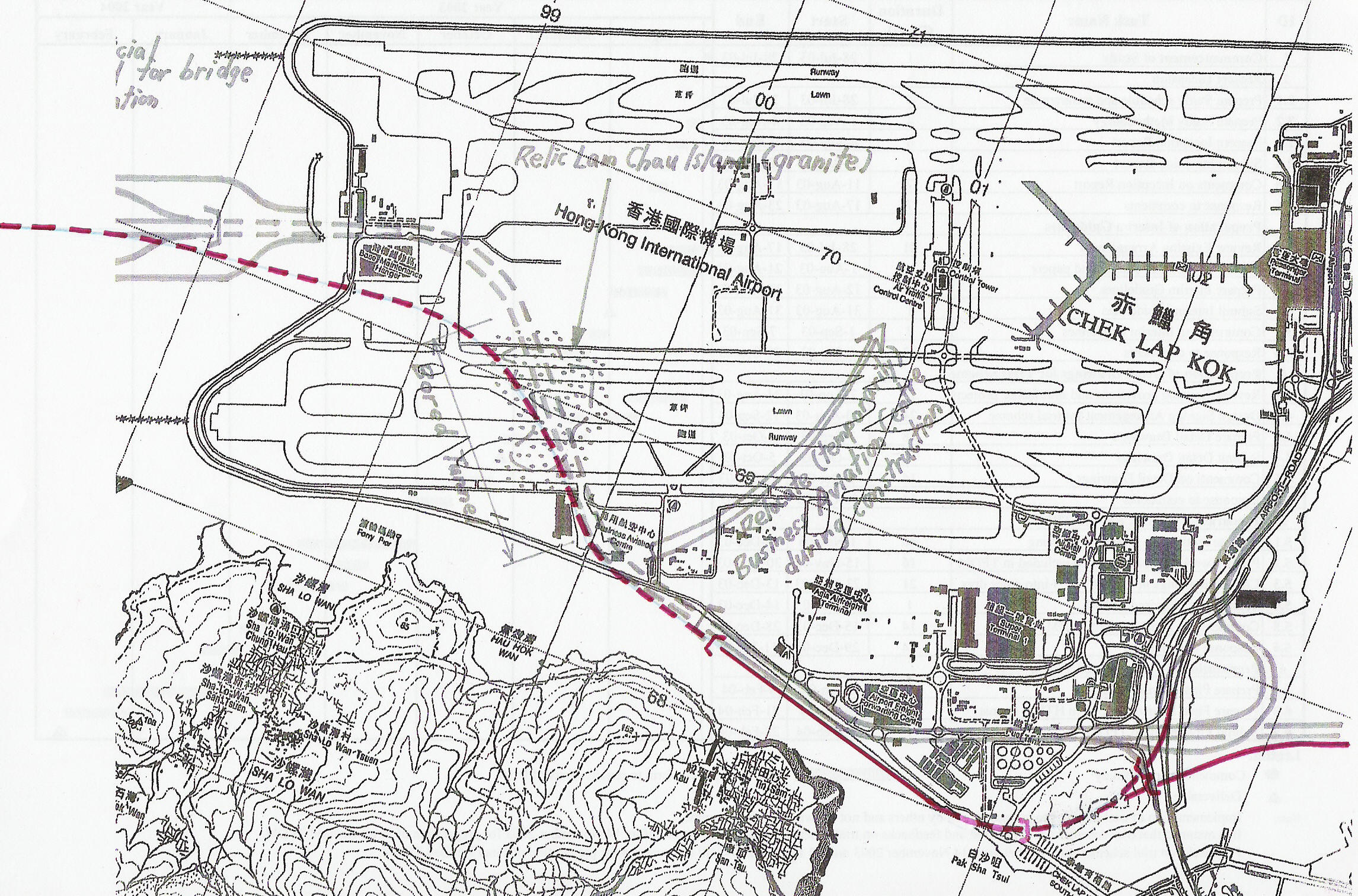
This newly generated option (Figure 1) involves a bored tunnel
traversing the south runway. This will almost completely avoid
impinging on the shorelines. A study of the geological map
indicates that both the south runway and the main taxiway
lie exactly over the relic “Lam Chau Island” which
is made of granite. Construction across the runway will be
highly feasible since the tunnel can be bored underneath in
solid rock by modern tunnel boring machine (TBM). The proposed
bored tunnel section will be about 1km long to ensure no disruption
to air traffic. Other sections of the tunnel will be constructed
by the cut and covered method. Construction across aircraft
accesses for the maintenance area should not pose a problem
given the possibility of sequential construction and the availability
of land.
The proposed approach route goes into a 2.8km long tunnel
between the east portal near the Commercial Aviation Centre
and an artificial island west of the Base Maintenance Hangar.
The route passes between the hangar and the marine rescue
centre. In fact, there are several possibilities of the precise
routing.
The existing Commercial Aviation Centre consists of several
smaller structures. It is proposed to relocate the facility
temporarily into the unused mid-field area adjacent to the
airport control tower. The relocated site is readily accessible
and should not cause any inconvenience to users. There will
be no disruption to the Government Flying Service base.
A two-way interchange can be provided east of the tunnel
entrance to serve the various freight terminals. The preferred
maximum gradient is 3-4% on approaches to tunnels and bridges.
The tunnel descends to the level of -20 to -30mPD underneath
the runway. A curve radius not less than 600m is provided
inside the tunnel section east of the hangar. This is satisfactory
for highway operation.
The eastern part of the proposed route probably follows the
current routing envisaged by Government. There are some remaining
natural shorelines between the Dragonair building and Pak
Sha Tsui. Reclamation of these natural shorelines should be
avoided.
Access to the inter-runway area- The 200 Ha site between
the two runways (mid-field area) has been designated a passenger
terminal area together with other freight and cargo facilities.
The current drawback is the lack of a high capacity access.
The proposed option opens up the possibility of a highway
linkage in both directions. Cargo from Zhuhai and Macau can
also directly access the mid-field area. Access may be provided
by an independent linkage between the mid-field area and the
proposed artificial island. A highway interchange for this
linkage can be comfortably provided on the artificial island.
Compatibility with railway route- Railways generally require
more generous alignment. The routing is compatible with a
gentle railway route linking to the existing airport railway
(Figure 2).
Proximity to Government support facilities: In comparison
with the currently known options, the artificial island is
much closer to the airport island. Support from Government
services such as fire station, police will be at hand.
Less interference with aircraft paths: By positioning the
bridge between the two runways, the bridge is likely to have
less interference with flight paths, both during construction
and in operation. The proposed route is less likely to suffer
from aircraft noise, which can be a safety hazard for motorists.
Shape of the airport island- The airport shape has been specially
designed with an elegant aerial shape. This option preserves
this shape and actually enhances it with an additional offshore
island.
Visitors’ facilities- The proposed artificial island
has a superb view of the Pearl River Estuary and a magnificent
sunset. It may serve as a resting point with visitors’
centre, parking, restaurants and even dolphin watching facilities.
Option R1 should be further examined due to its merits in
operation and minimal impact on the natural shorelines of
northwest Lantau. The solution is technically feasible by
taking advantage of a bored tunnel through the relic Lam Chau
Island. Bridge operation is also satisfactory given the possibility
of effective traffic control measures prior to the tunnel
and on the artificial island. The artificial island will also
serve as an emergency response centre and possibly incorporate
visitors’ facilities. A major side benefit of this option
is provision of access to the inter-runway area.
 Impact on Chinese White (Pink) Dolphins
(Letter from SOS to Dr. Sarah Liao Sau-Tung - Secretary for
Environment, Transport and Works)
As an Appendix to our submission on minimizing the environmental
impact of Bridge Access roads, [Ed: see below] Save Our Shorelines
also proposes that the Administration should ensure that any
EIA studies undertaken for this project should be carried
out at a VERY EARLY stage in the process and not at the end
of the design and planning exercise, and that they should
focus in particular on the White Dolphin population in the
area.
Some initial points to be considered include scheduling of
works, reduction of sediment spread and noise / vibration
reduction.
Timing:
Surveys have shown that the Chinese White Dolphin population
in Hong Kong waters increases during the summer months when
the Pearl River delta influence extends further south into
the South China Sea due to the heavy rains. Bridge construction
work, dredging and other works to be undertaken in the Pearl
River estuary should be timed to avoid high population numbers.
In addition, while calving occurs throughout the year, there
appear to be more calves during the spring than at other times.
Care should be taken to avoid work where the mothers and calves
are swimming. Observation maps are available to clearly show
where populations of the dolphins have been recorded at different
times of the year.
Sediment Spread
Sediment spread from the works areas will disturb the dolphins
breeding and feeding patterns. The amount of potential sediment
in suspension will be dependent on the type of works, for
example site formation (building bridge abutments or intermediate
new islands for bridge piers) will produce a lot more than
just piling.
Site formation will result mainly in suspended sediment in
the upper and middle depths of the water column, whereas piling
may potentially produce suspended sediment near the seabed
(though casing should be used to minimize this.) Silt fences
are the usual way to deal with suspended sediment in the marine
environment and it is suggested that these will be applicable
here as they do have a relatively good track record in silt
reduction.
.
It is also suggested that as part of the construction monitoring
contract regular sampling of the water column (top, middle
and bottom) immediately adjacent to the silt fences should
be undertaken (say once a week) with an associated relevant
suite of laboratory tests undertaken. The EIA should give
a clear indication of what tests will be carried out as well
as alarm levels to be set.
Sound / Vibration
The use of bubble-nets should be proposed in the preliminary
design studies to minimise the effects of construction on
dolphins. These can reduce the effects of vibration and noise
propagation through the water.
Save Our Shorelines September 2003
Tuesday,
October 21, 2003 Copyright SCMP 2003
Roads scholar needs to do his homework
JAKE VAN DER KAMP
You may accuse journalists of not letting the facts get in
the way of a good story but I am pleased to tell you that
the transport industry can go one better. This month's award
for stretching the facts goes to Leo Leung Kwok-kei, executive
director of that corporate road enthusiast, Hopewell Holdings.
At the Pearl River Delta Conference last week, Mr Leung argued
that there were environmental and economic grounds for favouring
road over rail on the proposed bridge linking Hong Kong to
Zhuhai and Macau.His environmental argument is that
air pollution from cars can be reduced through the use of
environmentally friendly fuels and that rail produces pollutants
too.
His economic argument, an even greater stretch, is that rail
is much more costly than road. As evidence he cited figures
showing that Kowloon Motor Bus, with assets of $6.5 billion,
carries only marginally fewer passengers than do the Kowloon-Canton
Railway and the Mass Transit Railway combined, and these two
have a book investment cost of $186 billion in their networks.
Let us deal with the environmental angle first. Yes, it is
true that the railways use electricity and this comes from
coal-fired power plants that spew smoke and noxious gases
into the atmosphere. I cannot say whether they spew as much
per passenger carried as internal combustion engines do, but
I strongly doubt it.
More than that, however, they spew it all high into the atmosphere
rather than directly into my lungs as KMB buses do if I walk
down Nathan Road.
And as for Mr Leung's suggested fuel improvements, what are
we to make of all the talk in recent years about how our buses
now run on environmentally friendly fuels? Does he propose
taking out their diesel engines and putting in ones run on
liquefied petroleum gas? I would like to see it. This would
indeed be a world-beating engineering achievement for heavy
vehicles.
Now for the economic argument. The reason KMB invests far
less than the railway companies do for the number of passengers
carried is that KMB does not have to invest in roadways. We
build them for KMB out of the public purse and then let its
buses use them for free.
To put things into perspective, the cost of KMB's buses is
in its books at $4.73 billion, while the book cost of the
KCR's rolling stock is $4.29 billion. There is not much difference
there at all in investment costs.
The big item in the KCR balance sheet, however, is $43 billion
for construction in progress. This is not an investment cost
item that will ever trouble KMB.
The little snippet of fact that Mr Leung conveniently omitted
to mention is that, unlike KMB, the railway companies must
themselves pay every single cent of the cost of building their
rail networks and, particularly in the case of the MTR, go
to enormous extra expense to do so underground because we
consider this more convenient to us than rail built above
ground where KMB runs its buses.
Bear this in mind if you ask the obvious question - how much
would we really have to charge KMB for use of our public roads
in order to put its true costs on a like-for-like basis with
the railways? The question is not just one of how much it
costs to construct roads but of the opportunity cost of using
that valuable above ground space for something else.
In the case of the MTR there is no lost opportunity. We do
not build our homes and workplaces underground. But just think
of what we could do with some of the vast amount of space
that we now use for roads if we did not need quite so much
roadway. The opportunity cost of building road rather than
underground rail is enormous.
Look at it another way. The total length of our current rail
network is just over 150km. The total lane length of public
roads in Hong Kong is about 5,400km, 36 times as much. I recognise
that the roadways are used by more than buses alone but, even
so, these figures say that rail not only saves us valuable
development space but is a much more efficient people mover
than bus.
Hopewell Holdings has road on the brain and always has had
except for one calamitous rail investment in Bangkok. Although
I shall give Mr Leung's boss, Sir Gordon Wu Ying-sheung, full
credit for regularly stimulating needed debate on transport
issues, let us hope that our transport authorities give Hopewell's
latest road versus rail proposals only the feather weighting
they deserve in debate about the new bridge.
Email Jake van der Kamp at jakeva@scmp.com.
August 29, 2003
Hong Kong Government News
Development
Bridge landing points under study
Constructive discussions: Secretary for Environment, Transport
& Works Dr Sarah Liao says the Hong Kong-Zhuhai-Macau
Bridge landing points are still being studied. The Advance
Work Co-ordination Group had its first meeting in Guangzhou
and is confident that research work will begin promptly.
The Hong Kong-Zhuhai-Macau Bridge landing points are still
being studied, Secretary for Environment, Transport &
Works Dr Sarah Liao says, adding that the economic effectiveness
and environmental factors of the proposed locations will be
considered.
Speaking after the first meeting of the bridge's Advance
Work Co-ordination Group held in Guangzhou today, Dr Liao
said members exchanged views and held constructive discussions.
She said the group has full confidence that research work
on the project will promptly commence, and an expert group
will be set up to study the project's details if necessary.
Future meetings will be convened according to work progress
and needs.
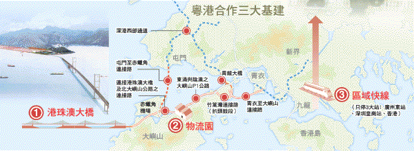
(Graphic below: Ming Pao 2003.07.31)
Tuesday, July 29, 2003
After a 15-minute trip across the bridge, a one-stop border
checkpoint would minimise delays for drivers
GARY CHEUNG
For motorists using the planned bridge across the Pearl River
Delta from Hong Kong to Macau and Zhuhai, cross-border hold-ups
are likely to be a thing of the past.
The mainland and both special administrative regions (SARs)
would perform immigration and customs checks at a shared checkpoint
built on reclaimed land, under a proposal being considered
by authorities on both sides of the delta.
A source close to Hopewell Holdings said the company had
recently raised the proposal with the authorities. Hopewell
chairman Sir Gordon Wu Ying-sheung is the main mover behind
the proposed 29km bridge.
With the bridge in place, travel between Hong Kong and the
west bank of the delta, on a six-lane highway, would take
just 15 minutes.
The source close to Hopewell said the "one-stop, three-checks"
proposal, using a shared checkpoint on a 900,000 sq metre
reclaimed island opposite the Gongbei land crossing between
Macau and Zhuhai, had received positive responses from authorities
on the mainland and in both SARs. "The authorities of
the three places will put [forward] the proposal for detailed
consideration in [a] further feasibility study on the project,"
the source said.
The source said a shared checkpoint could save drivers between
15 and 30 minutes per trip; drivers crossing the border at
Lok Ma Chau currently need up to two hours.
A shared border checkpoint will also be set up on the Western
Corridor linking Deep Bay and Shekou to simplify passenger
clearance.
Under Hopewell Holdings' proposal, the bridge would be in
two sections either side of a 1.4km tunnel between two artificial
islands. "The distance between the two artificial islands
would be wide enough to accommodate aircraft carriers,"
the source said.
Underpasses would be built in southwestern Zhuhai to connect
the bridge with the Beijing-Zhuhai superhighway and the road
network serving southwestern China.
It is understood the Hong Kong-Guangdong Co-operation Joint
Conference will discuss the bridge plan at a meeting this
weekend.
A feasibility study conducted by an institute under the National
Development and Reform Commission has explored three possible
options for a bridge spanning the Pearl River Delta. The study,
which was completed last week, concluded that a Y-shaped bridge
linking northern Lantau island to Macau and Zhuhai should
go ahead as soon as possible. The other two options are the
Lingdingyang bridge proposed by authorities in Zhuhai, part
of which has already been built, and a bridge further north,
running through Nansha to Shekou.
The study was commissioned by the Hong Kong government and
the development commission under the State Council. The Hong
Kong government's proposal recommends building a Y-shaped
link from San Shek Wan, north of Chek Lap Kok airport, to
Macau and Zhuhai. The study says the Y-shaped bridge linking
Hong Kong with Zhuhai and Macau would boost the economic development
of Hong Kong and the west side of the delta.
It is still unclear how soon work could begin on the bridge,
or how it would be funded. It would cost an estimated $15
billion and would take three to four years to build.
Sir Gordon has pledged to spearhead a consortium to fund
the project, and Macau casino mogul Stanley Ho Hung-sun and
Sun Hung Kai Properties have expressed interest in investing
in it.
Copyright © 2003. South China Morning
Post Publishers Ltd. All rights reserved.
 Wednesday,
July 16, 2003
Wednesday,
July 16, 2003
Delta bridge report expected next week
by GARY CHEUNG
The feasibility study on a bridge linking Hong Kong with
the west side of the Pearl River Delta is expected to be completed
next week, according to an official.
Secretary for Environment, Transport and Works Sarah Liao
Sau-tung yesterday said the study by an institute under the
National Development and Reform Commission was scheduled to
be finalised next week.
The study was jointly commissioned by the Hong Kong government
and the national commission.
Dr Liao said the work on the cross-delta bridge would proceed
in accordance with "normal procedures" once the
report was endorsed by the central and the Hong Kong governments.
It is understood that the study has endorsed the need for
the project because it will boost economic development and
help regional integration.
Premier Wen Jiabao told pro-Beijing politicians during his
visit to Hong Kong two weeks ago that he supported building
a bridge linking Hong Kong with the west bank of the Pearl
River Delta.
The two-day meeting of the Hong Kong-Guangdong Co-operation
Joint Conference was to have been held on July 8 in Hong Kong,
when discussions were expected to focus on the cross-delta
bridge.
But the meeting was postponed because of the Article 23 political
crisis. It is understood that the meeting will be resumed
at the end of this month or early next month.
Dr Liao said the government still had to conduct
an environmental impact assessment on the bridge in accordance
with law.
The Hong Kong side has recommended a 29km bridge linking
San Shek Wan, south of Chek Lap Kok airport, to Zhuhai and
Macau.
New landing point in HK for delta bridge proposed
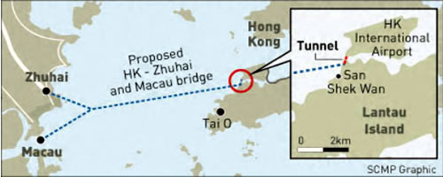
DENISE TSANG, SCMP 26 February 2003
The proposed cross-border bridge will start at San Shek Wan
in northern Lantau, rather than Tai O, to preserve the island's
coastline, the government said yesterday.
A senior government source said the 28km bridge - connecting
Hong Kong with Zhuhai and Macau - would be linked to the nearby
Chek Lap Kok airport through a tunnel in a design similar
to the two-level Tsing Ma Bridge.
This means that space will be reserved for a rail track connecting
to the Airport Express, the official said.
The bridge, which has obtained the blessing of the central
government, is expected to fuel further trade, traffic flow
and tourism in the Pearl River Delta.
The decision was made in order to preserve the spectacular
coastline around Tai O, which lies further to the south on
Lantau.
"We don't want to damage the coastline,"
the source said. "This was a key principle from the first
day of planning."
The alignment effectively means the proposal of a double
Y-shaped bridge landing at Tuen Mun has been ruled out.
"We already have a number of corridors linking to Shenzhen.
The latest is the Shenzhen Western Corridor highway between
Deep Bay and Tuen Mun," the source said.
The Lantau alignment will form the core of a feasibility
study co-funded by the Guangdong and Hong Kong governments,
which is due to be completed in June.
Seven representatives of the State Development Planning Commission
are to visit Hong Kong today as part of the feasibility study
after touring Macau last week.
Another key issue - the environmental impact of the bridge
- will also be studied. In December Guangdong Governor Lu
Ruihua appeared cool towards the project after meeting Chief
Executive Tung Chee-hwa in Guangzhou, saying there were many
ecological factors to consider.
But the source said: "I don't think the environmental
assessment will cause big problems because a similar study
was done and debated on the bridge's predecessor, the Lingdingyang
bridge."
Funding of the bridge, which is estimated to cost $13 billion,
is no problem. A private consortium led by the chairman of
Hopewell Holdings, Gordon Wu Ying-sheung, and Stanley Ho Hung-sun,
chairman of Shun Tak Holdings, have said they will invest.
"It is good news that the bridge has attracted keen
interest from private investors," the source said.
"Their participation is important to the project."
Last year the Financial Secretary, Antony Leung Kam-chung,
said the Hong Kong government had the resources to finance
the bridge if necessary.
To improve the transport network in the western New Territories
and Lantau, the government plans to build a 9km rail and road
corridor between the airport and Tuen Mun.
This will possibly link the Tuen Mun terminus of the Kowloon-Canton
Railway Corporation's West Rail and the Airport Express, forming
a rail loop in Lantau, west Kowloon and Hong Kong Island.
 INTRODUCTION
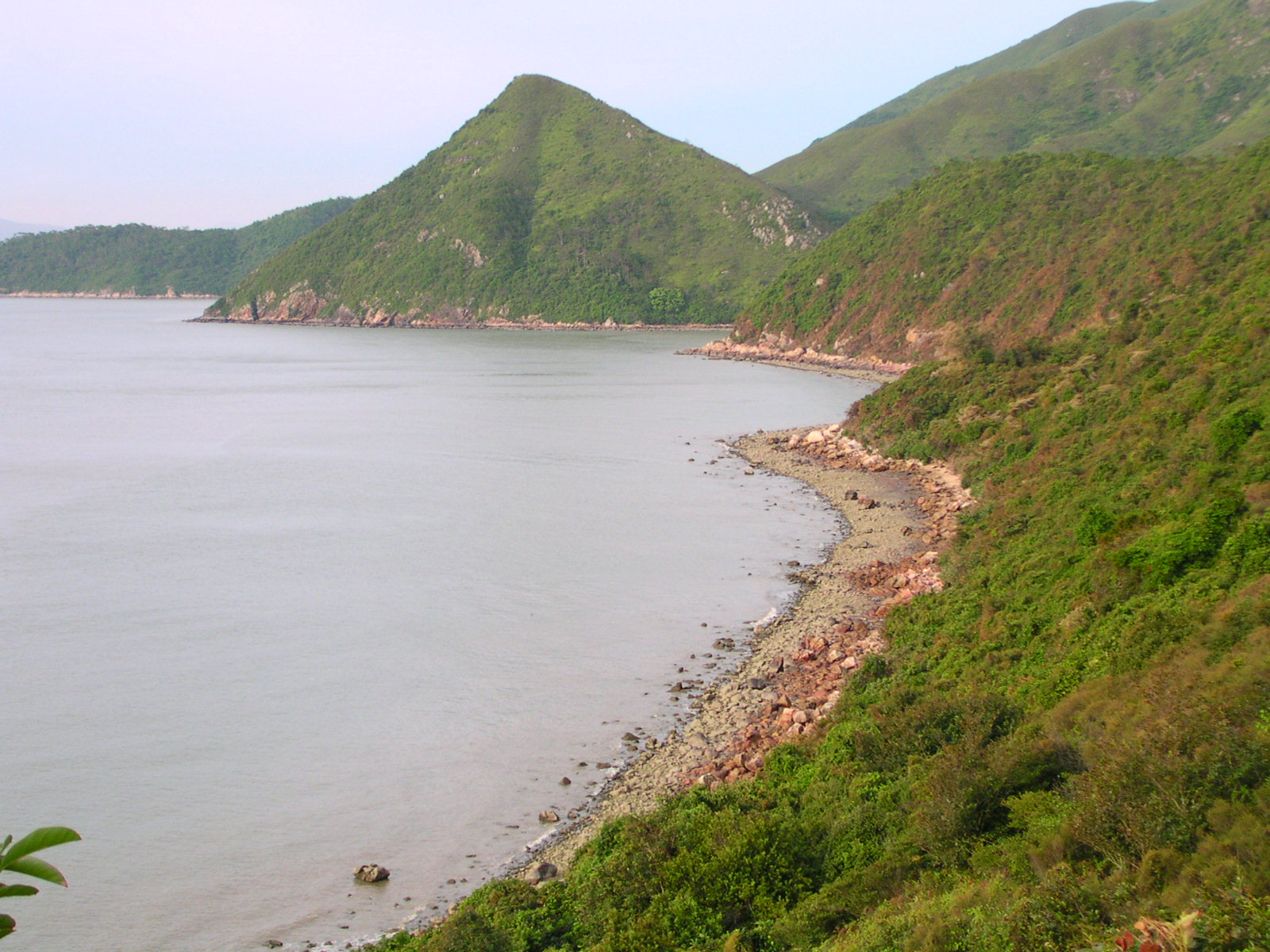 GEOLOGICAL
LANDSCAPE
GEOLOGICAL
LANDSCAPE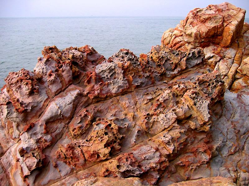 Highly
scenic reddish shorelines are confined to only two
areas in Hong Kong. The first area is in the Northeast New
Territories around the well known Double Haven coast. The
second area, less known to the general public, is along the
northwestern shore of Lantau Island between Sham Shek Wan
and Tai O. Here the reddish colourful shoreline originates
from a unique formation of Jurassic age sedimentary rocks.
This rock formation also stands out as two extraordinary escarpment
features guarding the mouth of the indented bay of Sham Wat.
Highly
scenic reddish shorelines are confined to only two
areas in Hong Kong. The first area is in the Northeast New
Territories around the well known Double Haven coast. The
second area, less known to the general public, is along the
northwestern shore of Lantau Island between Sham Shek Wan
and Tai O. Here the reddish colourful shoreline originates
from a unique formation of Jurassic age sedimentary rocks.
This rock formation also stands out as two extraordinary escarpment
features guarding the mouth of the indented bay of Sham Wat.
 In
addition to ecological importance, the shoreline
along northwestern of Lantau Island, therefore, has very special
values in landscape scenery, geology and education. Unfortunately,
all these are highly vulnerable to disturbance and irreversible
destruction by any major coastal highway infrastructures,
notably the proposed bridge link.
In
addition to ecological importance, the shoreline
along northwestern of Lantau Island, therefore, has very special
values in landscape scenery, geology and education. Unfortunately,
all these are highly vulnerable to disturbance and irreversible
destruction by any major coastal highway infrastructures,
notably the proposed bridge link.